Boyne Valley Guide
 Boyne Valley heritage guide.
Archaeological & Historical Timeline
Trim Heritage Town & Trim Castle,
Bective Abbey, Skryne, Ardmulchan
Hill of Tara, Navan Town
Brú na Bóinne - Newgrange & Knowth
Duleek Abbey
Battle of the Boyne
Drogheda Town
St. Peter's Church, Highlanes Gallery
Drogheda Museum, Millmount
Beaulieu House
Monasterboice
Old Mellifont Abbey
Townley Hall, Francis Ledwidge Museum
Slane Village & Slane Castle
Hill of Slane, Dowth
Donaghmore Round Tower, Donaghpatrick
Kells Town & Monastic Site
Spire of Lloyd, Patrickstown View, Oldcastle
Loughcrew Gardens & Cairns
Myths & Legends
Download Boyne Valley Guide - PDF format.
For outdoor activities, towns, gardens, food and festivals, see the
Discover Boyne Valley holiday guide.
The Boyne Valley
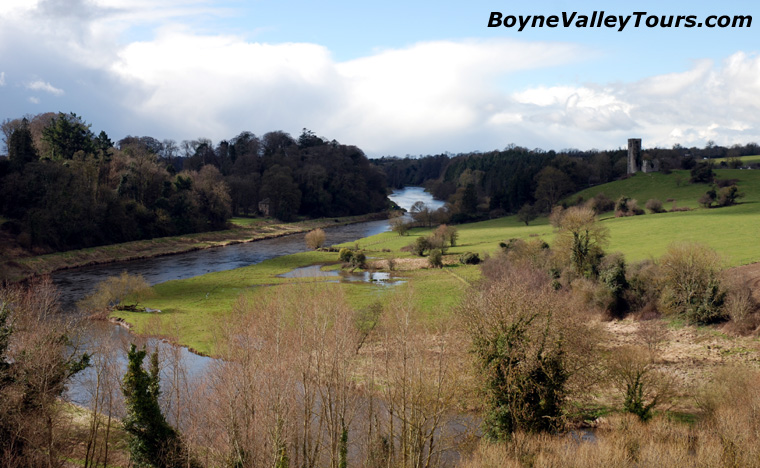
The River Boyne from Ardmulchan, with church ruins and a round tower on the hill beyond.
The Boyne Valley is situated in the east of Ireland. It is at once Ireland’s ancient capital and its most sacred and mythical
landscape. In 1849 William Wilde, father of Oscar, wrote of the Boyne that the history of Ireland may be traced through its
monuments. This remains true today. Moreover, its sites and monuments are among the best examples of their kind in Europe
and are all within a short distance of each other.
In one day you can visit the great prehistoric tombs at Brú na Bóinne (Newgrange) and the site of the
infamous Battle of the Boyne. You can look out from the
Hill of Tara, sharing the view with the ancient High Kings of Ireland, or be mesmerized by the detail
of the Celtic crosses at Kells. You can stand in awe at the gates of
Trim Castle, the largest Anglo-Norman castle in Ireland, or pay your respects at the shrine of
St. Oliver Plunkett in Drogheda.
The River Boyne is the principal waterway in Leinster. It rises at Trinity Well, near Carbury,
County Kildare, and meanders slowly northeast through the fertile plains of County Meath before entering the Irish Sea at
Drogheda, County Louth. The richness of the soil was ideal for Neolithic farmers, who began to arrive in Ireland around
4,000 BC. The east coast between Dublin and Drogheda is among the driest parts of the country and well suited to growing crops.
Long before roads, the river was vital for travel and trade. Its name derives from the legendary Celtic goddess Bóann.
Exploring the Boyne Valley by private tour allows the landscape to be experienced at a natural pace.
Rather than rushing between highlights, each site can be placed in context, with time for explanation,
short walks, photography stops, and quieter locations that are often missed on standard group itineraries.
Archaeological and historical timeline
The story of the valley begins about 9,000 years ago, after the ice sheets of the last Ice Age had retreated.
Mesolithic hunter-gatherers arrived around 7000 BC. Neolithic farmers followed from about 4000 BC, and by around 3200 BC
the great passage tombs of Newgrange, Knowth and Dowth were under construction, with the Loughcrew cairns following
around 3000 BC.
Early activity at Tara continued into the Iron Age and Early Christian period. In 433 St. Patrick is traditionally said to have
lit the Paschal fire on the Hill of Slane. Monasterboice was founded in the early Christian centuries; Mellifont Abbey followed
in 1142. The Anglo-Normans arrived in 1169, Henry II granted Meath to Hugh de Lacy in 1172, and Trim Castle rose soon after.
Later landmarks include the Battle of the Boyne in 1690, the “discovery” of Newgrange in 1699, and UNESCO World Heritage
status for Newgrange, Knowth and Dowth in 1993.
Brú na Bóinne: Newgrange, Knowth, and Dowth
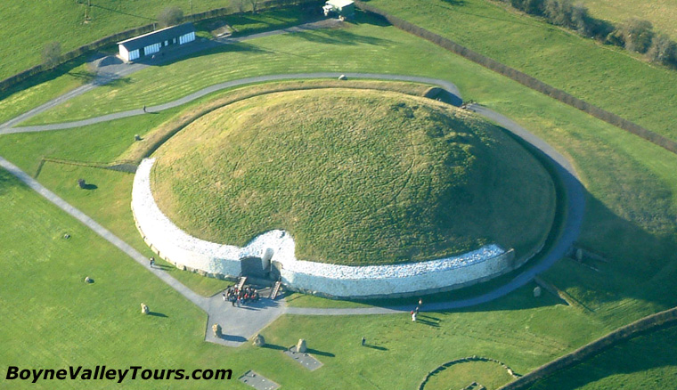
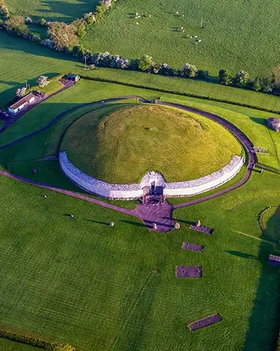
Newgrange passage tomb in the Brú na Bóinne UNESCO World Heritage landscape.
Brú na Bóinne is one of the largest and most important prehistoric megalithic landscapes in Europe. Situated on the north bank
of the River Boyne about 8 kilometers (5 miles) west of Drogheda, it is dominated by three great passage tombs:
Newgrange, Knowth and Dowth, declared a UNESCO
World Heritage Site in 1993.
Passage tombs consist of a burial chamber reached by a long straight passage lined with stones, set within a large mound or cairn.
They are usually sited on hilltops and grouped in cemeteries. Although primarily burial places, they also served as status symbols,
focal points for the community, places to honor ancestors, and territorial markers. Constructed in the Neolithic period, the tombs
at Brú na Bóinne are around 5,000 years old. The builders were farmers, yet they also possessed expertise in engineering, geology,
art and astronomy.
At dawn on the morning of the winter solstice, and for a number of days before and after,
the main chamber at Newgrange is illuminated by a beam of sunlight for about 17 minutes. The alignment is too precise to have
occurred by chance. Newgrange is thought to be among the oldest surviving deliberately aligned structures in the world.
Constructed around 3200 BC, it is about 500 years older than the pyramids of Egypt and about 1,000 years older than Stonehenge.
Activity continued for millennia after the tombs were built. Knowth, for example, later served as a burial site in the Iron Age,
as a royal seat of the kings of Northern Brega in the Early Christian period, and as an Anglo-Norman motte in the medieval period.
There is no direct public access to Newgrange and Knowth; admission is through the Brú na Bóinne Visitor Center near Donore,
with shuttle buses to the monuments. Knowth has about 45% of all the art known from Irish tombs and nearly 30% of all the
megalithic art in Europe: spirals, lozenges, chevrons, triangles and arrangements of parallel lines and arcs.
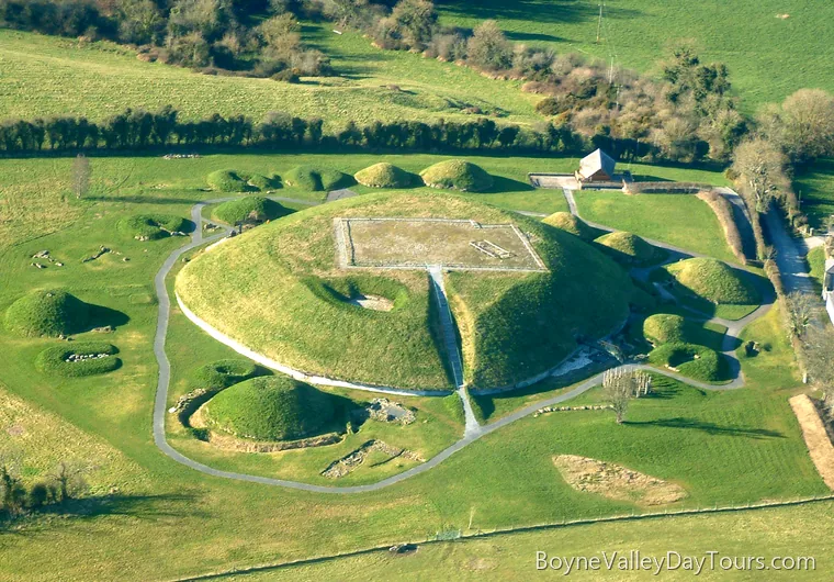
Knowth from above, with the great mound and surrounding satellite tombs.
Together with Newgrange and Knowth, Dowth completes the Brú na Bóinne passage tomb complex.
The mound was damaged by a blast of dynamite in 1847 during crude excavation or plundering, which opened two passage tombs.
With shorter passages and lower roofs they are less spectacular than Newgrange or Knowth, yet still worth visiting.
As at Newgrange, an entrance is aligned so that winter solstice light moves along the passage into the chamber.
The Hill of Tara and the ceremonial landscape
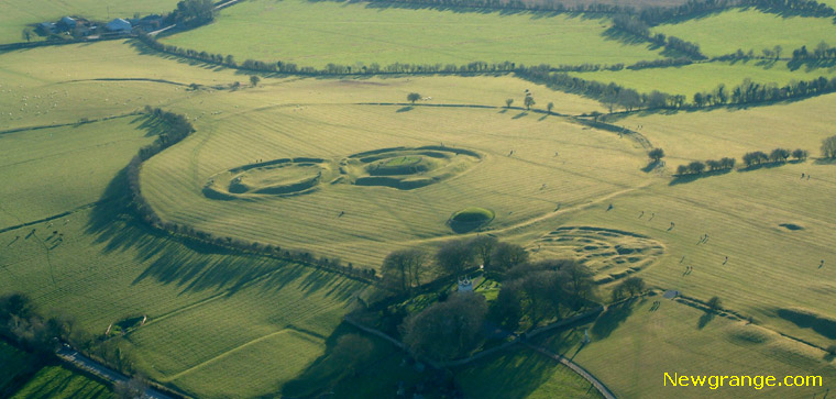
The Hill of Tara, ancient ceremonial center and seat of the High Kings of Ireland.
The Hill of Tara was the seat of the High Kings of Ireland and the most sacred site in ancient Ireland.
It is a low-lying ridge between Navan and Dunshaughlin. Tara takes its name from Teamhair na Rí, meaning “sanctuary of the kings,”
and it is important as the traditional inauguration place of the ancient High Kings. Although few monuments survive intact,
it remains an evocative place, much celebrated in Irish myth and legend.
Tara was important long before the High Kings. A passage tomb known as Dumha na nGiall, the Mound of the Hostages, is the oldest
visible monument and dates from around 3000 BC. Tara became especially significant in the Iron Age (about 600 BC to 400 AD)
and into the Early Christian period. It was the royal center of Mide, “the middle kingdom,” incorporating present-day County Meath,
Westmeath and parts of Cavan and Longford. From the 9th century the title King of Tara became synonymous with the High King of Ireland.
One of the most interesting monuments is the Lia Fáil, the Stone of Destiny, a standing stone within the Forrad, the Royal Seat.
According to tradition, when a true king placed his foot on the stone it cried out to announce his rightful reign.
Other earthworks include Teach Miodhchuarta (the Banqueting Hall), Rath na Rí (the Fort of the Kings), Teach Cormaic
(Cormac’s House), Rath Gráinne, Rath na Seanadh (the Rath of the Synods) and Claoin Fhearta (the Sloping Trenches).
Although Tara was abandoned as a royal seat by Mael Shechlainn in 1022, it continued to play a symbolic role.
In 1843 an estimated one million people gathered there to hear Daniel O’Connell speak against the Union.
A private hire visit to Tara focuses on interpretation rather than spectacle,
helping visitors understand how the site functioned and why it remained significant for so many centuries.
Trim Heritage Town and Trim Castle
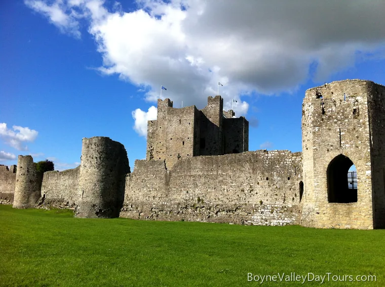
Trim Castle, the largest Anglo-Norman castle in Ireland.
Trim contains more medieval buildings than any town in Ireland. Situated on the banks of the Boyne in fertile plains,
the town developed around Trim Castle, straddling the river to the north and west of the fortress.
In the 13th century it was enclosed within stone walls. Augustinian, Franciscan and Dominican friaries were established,
indicating growing prosperity. In the later medieval period Trim became an exposed frontier between the Anglo-Norman and Gaelic worlds.
Fragments of the medieval town are still clearly visible. The Sheep Gate is the only surviving medieval gateway.
The jagged Yellow Steeple was formerly a seven-storied church tower of St Mary’s Augustinian Abbey, named for the color of the
stonework in the evening sun. Ireland’s oldest complete and unaltered bridge, dating from 1393, crosses the Boyne at Trim.
A few kilometers downstream stand the ruins of Newtown Trim: a large medieval cathedral, two monasteries and a small church.
Trim takes its name from the Irish Áth Truim, meaning “the Ford of the Elder Trees.” In 1172, shortly after the Anglo-Norman arrival,
King Henry II granted Hugh de Lacy the Kingdom of Meath. De Lacy made Trim, rather than Drogheda, the center of his new lordship
and converted a ringfort into a wooden castle. In 1174 Rory O’Connor, King of Connacht and last High King of Ireland, attacked and
destroyed it. The following year work began on a permanent stone replacement. Over the following decades Hugh de Lacy and his son
Walter constructed the largest Anglo-Norman castle in Ireland. Most of what is visible today was completed by about 1220.
The unique twenty-sided cruciform design of the keep, with walls about 3 meters (10 feet) thick, is an example of experimental military
architecture of the period. Trim Castle later served as a “castle double” for York Castle in Mel Gibson’s film Braveheart.
Private day tour · About 8 hours
Ideal for a first visit to the Boyne Valley, this private tour explores the UNESCO World Heritage landscape of Brú na Bóinne.
Visit Newgrange and Knowth with the official site guides,
then discover places associated with Ireland's ancient kings, mythology, and Saint Patrick.
The day also includes the Hill of Slane and the Hill of Tara.
Price €675 for up to six guests, plus booking fees.
Bective Abbey, Skryne and Ardmulchan
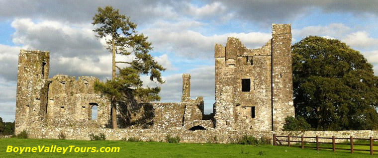
Bective Abbey, Cistercian daughter house of Mellifont.
Bective Abbey was founded in 1147 for the Cistercian Order by Murchad O’Maeil-Sheachlainn, King of Meath.
It was Ireland’s second Cistercian abbey, a daughter house of Mellifont. Suppressed under Henry VIII in 1543, the monastery later
served as a fortified house. The remains date mainly from the 13th to 15th centuries and include the church, chapter house and
a well-preserved cloister with pointed Gothic arches. Today the ruins form a maze of passageways, dead ends and interrupted staircases.
On the Hill of Skryne, a 15th-century church ruin known locally as Skryne Tower displays medieval pointed arches and an impressive tower.
The name Skryne derives from Scrín Cholm Cille, “Colmcille’s shrine,” linked with St. Columba, founder of the monastery at Kells.
Nearby, the ruins of Ardmulchan Church and graveyard occupy an elevated site overlooking the Boyne,
with fine views toward Dunmoe Castle, Donaghmore round tower and the belfry of Slane Abbey.
Monasterboice and Mellifont Abbey
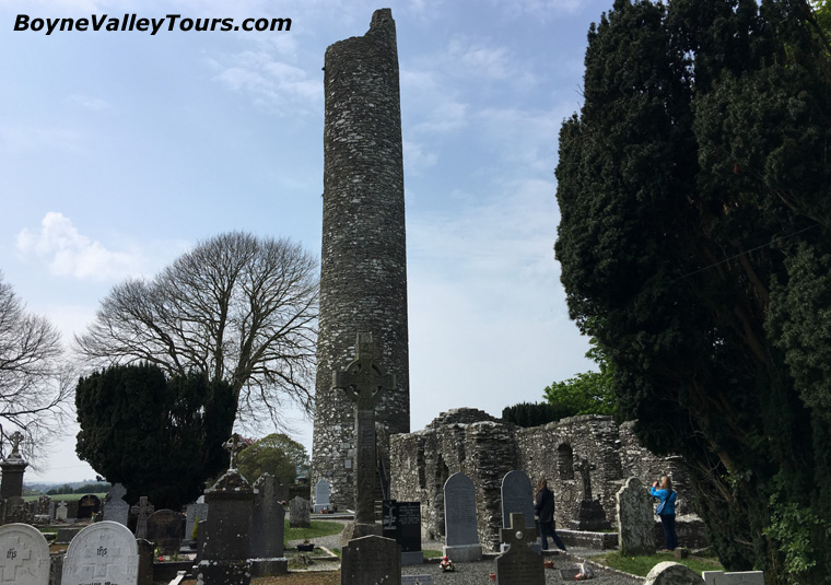
Monasterboice round tower, high crosses and monastic ruins.
Christianity was introduced into Ireland, probably from Roman Britain, during the 5th century AD.
Monasterboice is one of Ireland’s earliest and best-known religious sites.
Its name derives from Mainistir Bhuithe, “the monastery of Buite.” St. Buite, a follower of St. Patrick, died in 521
on the day St. Columba was born. The site comprises two churches and a round tower. The Irish name for such towers,
cloigtheach, meaning bell house, hints at their function. The tower at Monasterboice was burned in 1097, destroying the
monastic library and other treasures, yet it remains in excellent condition though without its conical cap.
It is the second tallest round tower in Ireland.
The site contains two of the finest High Crosses in Ireland, dating from the 9th century: the South Cross, or Cross of Muiredach,
and the West Cross, or Tall Cross. Standing almost 5.5 meters (18 feet) high and carved from a single block of sandstone, the Cross of
Muiredach is arguably the finest High Cross in Ireland. An inscription asks for a prayer for Muiredach, thought to be
Muiredach Mac Domhnaill, abbot from 890 to 923. The Tall Cross is the tallest high cross in Ireland at around 7 meters (23 feet).
Today the High Cross is recognized internationally as a symbol of Irish cultural heritage as well as a religious icon.
Mellifont Abbey was one of the wealthiest and most influential monastic houses in medieval Ireland.
Situated in a tranquil valley on the banks of the River Mattock, a tributary of the Boyne, its name comes from the Latin
Fons Mellis, “fountain of honey.” St. Malachy of Armagh, with Irish and French monks trained at Clairvaux, founded Mellifont
in 1142 on lands granted by Donogh O’Carroll, King of Oriel. It was the first Cistercian monastery established in Ireland,
and over 20 other Cistercian houses were founded directly or indirectly from it.
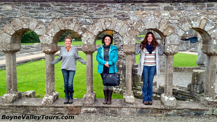
The octagonal lavabo at Old Mellifont Abbey.
The abbey was consecrated in 1157 at a national synod attended by Murtaugh MacLochlainn, High King of Ireland.
Mellifont heralded a new era: older Irish monasteries such as Monasterboice were largely independent spiritual centers,
while Mellifont followed the European cloistral plan, with buildings around a central open space. Its distinguishing feature
is an octagonal lavabo of about 1200, where monks washed their hands before prayer. Lavabo means “I shall wash.”
Dissolved in 1539, Mellifont later saw Hugh O’Neill submit to Lord Mountjoy in 1603, signing the Treaty of Mellifont.
During the Battle of the Boyne in 1690, King William based his headquarters here.
Battle of the Boyne
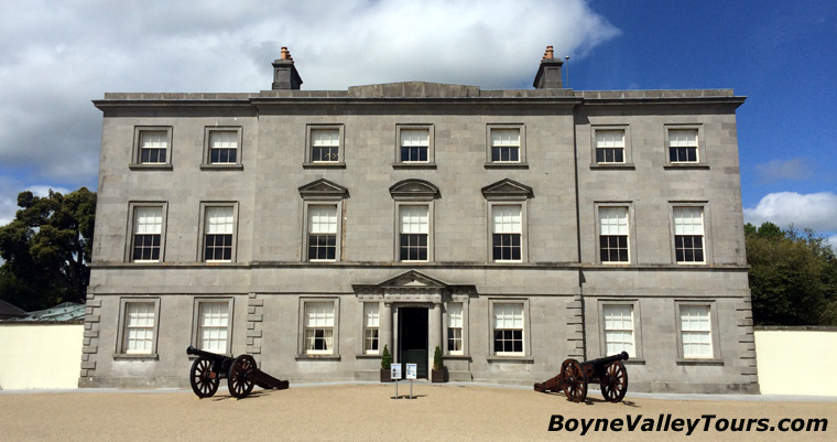
Oldbridge House, home of the Battle of the Boyne Visitor Center.
The Battle of the Boyne was fought between King William III and his father-in-law King James II
on 1 July 1690. The kings were rival claimants to the English, Scottish and Irish thrones. Protestant King William of Orange
had deposed Catholic King James in 1688. William’s army of some 36,000 men included English, Irish, Scottish, Dutch, Danish
and Huguenot troops. The opposing Jacobite army was mainly Irish Catholics, reinforced by about 6,500 French troops sent by
Louis XIV.
The Jacobites chose the Boyne as the best defense against Williamite progress south toward Dublin. A force of about 25,000 men
was positioned at Oldbridge, the most likely crossing point. William sent a force of 10,000 toward Slane, drawing the bulk of
the Jacobites upstream, then crossed at Drybridge with mounted troops while the main assault went in at Oldbridge.
Of the 61,000 men who fought, relatively few were killed: about 1,000 Jacobites and 500 Williamites. William’s victory was the
turning point in James’s unsuccessful attempt to regain the Crown and ensured the continuation of Protestant supremacy in Ireland.
The Battle of the Boyne Visitor Center is in the restored 18th-century Oldbridge House on the battlefield.
Slane, Drogheda, and the middle Boyne
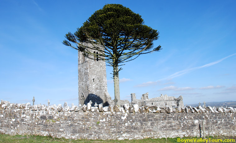
The Hill of Slane, traditionally linked with Saint Patrick.
The Hill of Slane rises about 158 meters (518 feet) above the surrounding countryside and can be seen from
Tara about 16 kilometers (10 miles) away. Among the ruins of a Franciscan monastery dating from 1512, itself built on the site of a
monastery founded by St. Erc, a follower of St. Patrick, stands a well-preserved tower. Legend holds that in 433, in defiance
of the pagan High King Laoghaire, Patrick lit a Paschal fire on the Hill of Slane. Though angry, Laoghaire was so impressed by
Patrick’s devotion that he allowed him to continue his missionary work.
Slane village was laid out in the 1760s by the Conynghams. The center of the village, known as the Square though actually an
octagon, has four identical Georgian houses called the Four Sisters. Slane Castle, set on a
magnificent 607 hectare (1,500 acre) estate just upriver from the battle site, was reconstructed from 1785 with work by James Gandon and
Francis Johnston. The parklands were laid out by Capability Brown. In modern times the castle’s natural amphitheater has hosted
major outdoor concerts, and U2 recorded part of The Unforgettable Fire there.
Drogheda derives its name from Droichead Átha, “Bridge of the Ford.” It began as an Anglo-Norman port
founded by Hugh de Lacy and developed as two settlements on opposite banks of the Boyne estuary. Granted a charter in 1194,
it became one of the largest walled towns in medieval Ireland. St. Laurence’s Gate, with two lofty circular towers joined by a wall
and archway, is widely regarded as one of the finest of its kind in Europe. In 1494 Parliament met at Drogheda and enacted
Poynings’ Law. In 1649 Cromwell breached the walls and sacked the town. Millmount Museum and Martello Tower stand on high ground
overlooking the river, on a mound traditionally linked with the Milesian bard Amergin and possibly a large passage tomb.
St. Peter’s Church houses the shrine of St. Oliver Plunkett, the last Catholic martyr to die in England.
Nearby, Duleek Abbey began as a monastic settlement when, around 450, St. Patrick established a bishopric
there. The name Duleek comes from Damhliag, “stone house or church,” and refers to an early stone building, possibly the first of
its kind in Ireland. The impressive ruins are mainly those of an Augustinian priory established in the 12th century, with a
beautiful 9th-century High Cross outside.
Kells, Navan and the western valley
The heritage town of Kells derives from Ceanannas Mór, “great residence.” Long before Christianity it was
a royal residence associated with Conn of the Hundred Battles and Cormac mac Airt. In 550 St. Columba established a religious
settlement here. After Viking raids on Iona, the community of St. Columba was granted lands at Kells as a safe haven.
The most famous treasure associated with the community is the Book of Kells, a highly ornate Latin gospel book written around
the year 800. Kells round tower stands about 25 meters (82 feet) high, surrounded by finely carved high crosses. St. Columba’s House,
a 9th-century stone oratory with a steeply pointed stone roof, is among the oldest surviving structures in the town.
Navan lies at the confluence of the Boyne and Blackwater and is the county town of Meath. The Anglo-Normans recognized the
strategic importance of the location; around 1185 Joselyn de Angulo converted a nearby glacial mound into a motte and bailey.
The ruins of Athlumney Castle face Navan across the Boyne. Navan was the birthplace of Francis Beaufort, who developed the
Beaufort Scale of wind force, and the childhood home of Pierce Brosnan. It remains a convenient base for touring Brú na Bóinne,
Tara, Kells and Trim, with riverside walks along the Boyne and canal.
West of Kells, the Spire of Lloyd is an 18th-century folly, the only inland lighthouse in Ireland: a Doric column topped with a
glazed lantern, erected in 1791 in memory of Thomas Taylor, 1st Earl of Bective. On a clear day the views reach as far as the
Mourne Mountains. Near Oldcastle, Patrickstown Viewing Point looks toward Patrick’s Hill, one of the three hilltops of the
Loughcrew complex.
Loughcrew: equinox light and hilltop cairns
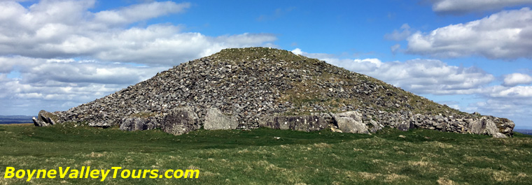
Loughcrew Cairn T on Carnbane East.
Loughcrew, with a concentration of around 30 passage tombs, is one of the most important prehistoric
cemeteries in Ireland. The complex sits around the summits of three hills near Oldcastle: Carnbane East, Carnbane West and
Patrickstown. Nearby are the restored 17th-century Loughcrew Gardens. Roughly contemporary with Newgrange (about 3200 BC),
the tombs were large communal burial places for Neolithic communities.
Cairn T on Carnbane East is particularly notable for its equinox alignment,
when sunlight reaches the chamber on mornings around the spring and autumn equinox.
The elevated position offers sweeping views and a strong sense of connection between monument, sky and landscape,
making Loughcrew one of the most memorable prehistoric sites in Ireland.
Myths and legends
The Boyne Valley is as rich in story as in stone. The river itself is named for Bóann, the Celtic cow goddess.
At Tara and Slane the legends of kingship and St. Patrick intertwine. In other tales, Fionn mac Cumhaill captures the
Salmon of Knowledge in the Boyne, while Milesian invaders such as Éremón and the bard Amergin are linked with places
around Navan and Millmount. These stories do not replace the archaeology; they help explain why the landscape has held
such power in the Irish imagination for so long.
Why explore the Boyne Valley by private hire
The strength of the Boyne Valley lies in its connections.
Private hire tours allow those connections to be explained clearly,
without fixed schedules or large groups.
Routes can be adjusted to suit interests, whether that is prehistory,
early Christianity, medieval Ireland, photography, or simply enjoying the landscape.
The result is a deeper understanding of the valley and a more relaxed experience overall.
The Boyne Valley is not a single attraction but a living historic landscape.
Exploring it with time, context, and flexibility reveals why it has remained central
to Ireland’s story for over five thousand years.
For outdoor activities, towns, gardens, food and festivals, see the
Discover Boyne Valley holiday guide
(with free PDF download and map).
Boyne Valley Food Series
The Boyne Valley Food Series serves to enhance and encourage a new wave of culinary tourist,
whether opportunistic or deliberate, to experience the very best of 'place on a plate',
the personalities behind that plate and the story behind the production.
Download Boyne Valley Food Series - PDF format.
TripAdvisor Review
What a wonderful day with Michael in the Boyne Valley. Not only did we learn about the ancient sites from the Stone Age to the Celts, we walked in their shadows. Michael is an excellent guide with humour and intellect.
Read the full TripAdvisor review