Medieval Walled Towns of Meath
County Meath is best known for its prehistoric monuments such as Newgrange and Knowth, but its medieval heritage is just as compelling. Across the county are the remains of four historic walled towns, each telling the story of Ireland’s transformation following the arrival of the Anglo-Normans in the late 12th century.
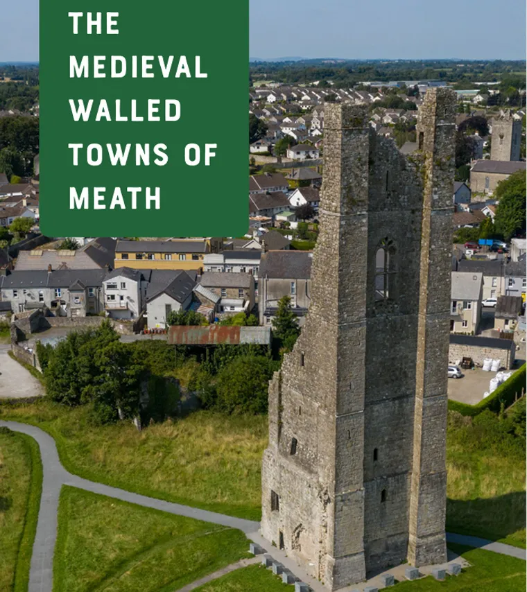
The Medieval Walled Towns of Meath | Download PDF.
These towns, Trim, Navan, Kells and Athboy, were once thriving centers of trade, defense and administration. Today, their streets, ruins and surviving walls offer a fascinating glimpse into medieval life. All four are members of the Irish Walled Towns Network.
What Was a Medieval Walled Town?
In medieval Ireland, towns were carefully planned centers of commerce and control. Following the Anglo-Norman invasion, settlements were established across the countryside and granted charters, allowing them to hold markets and fairs. At the end of the 12th century most Irish settlement was still rural, apart from Viking port towns such as Dublin, Waterford and Limerick. The new lords planted manors and towns, often bringing settlers from England and Wales. Many first spoke French. Over time English became the language of the towns. In later centuries an Irish settlement sometimes grew up beside a walled town and was known as Irishtown.
To protect these towns, defensive walls were constructed. Early defenses consisted of earthen banks and wooden palisades, but many were later rebuilt in stone using funds raised through taxes known as murage. Tolls were collected at the gates, of which there were rarely more than four. Towers along the circuit housed lookouts and archers. The walls were a show of wealth as well as a military barrier. They also made it easier to run a protected market.
Weekly markets were held in an open space inside the walls. Larger annual fairs took place outside, drawing merchants from further afield who sold spices, wine and fine cloth. Trades recorded in documents and excavations include brewing, woodworking, shoemaking, smithing, tanning and pottery. Most houses were timber. Stone was reserved for the castle, the parish church, and religious houses, which often stood just outside the gates.
The head of each household was a burgess, granted a long, narrow burgage plot with a house facing the street and a garden, workshops and animal pens behind. In several Meath towns those plot lines can still be read in modern property boundaries. The walls served multiple purposes, providing defense, controlling trade through gates, and marking a clear boundary between town and countryside.
The Norman Influence in Meath
The development of Meath’s walled towns is closely linked to Hugh de Lacy, the Anglo-Norman lord granted the former Gaelic kingdom of Mide by King Henry II. Henry was wary of the power of Richard de Clare, known as Strongbow, in Leinster. Granting the vast lordship of Meath to de Lacy, a Marcher lord from the Welsh border, helped to counter that influence. Medieval Meath was larger than the modern county. It included present-day Westmeath and parts of Offaly and Longford.
Hugh kept Trim and Kells as manors for himself. Athboy and Navan were granted to loyal knights. From this base, a network of fortified towns was established along the River Boyne and key trade routes. Trim and Navan sit on the river. Kells and Athboy grew on nearby roads. De Lacy also founded a town and port at Drogheda at the mouth of the Boyne, opening trade with western England and northern France. These towns acted as strongholds of Norman authority, particularly in the 15th century, when English control shrank to the Pale of Dublin, Meath, Kildare and Louth.
Trim - The Stronghold of Meath
Trim is the most impressive of Meath’s walled towns and remains one of the best-preserved medieval landscapes in Ireland. The name comes from Baile Átha Troim, the town at the ford of the elder tree. According to the Book of Armagh, Saint Loman founded a monastery here in AD 432. Excavations near St Patrick’s Cathedral, on Loman Street and Church Lane, found burials of the mid to late first millennium, confirming an early church on the north bank of the Boyne. The curve of Haggard Street may still follow the old monastic enclosure. A secular settlement grew on the south bank. Traces of 12th-century houses, predating the Normans, were found when Finnegan’s Way was built.
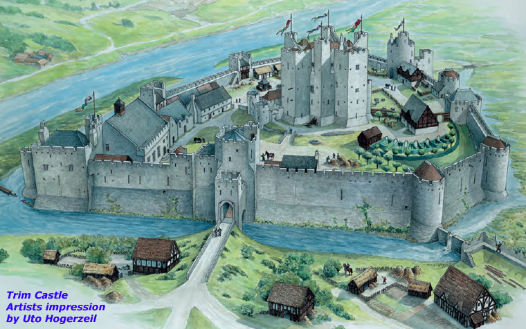
At the center of the later town stands Trim Castle, the largest Anglo-Norman castle in Ireland. Hugh de Lacy first fortified a house here, perhaps an existing Gaelic dún. That wooden ringwork was burned by forces of the high king Ruaidrí Ua Conchobair while Hugh was away. He rebuilt it, then replaced it in stone. Dendrochronology of scaffolding timbers dates the first stone phase to about 1175 to 1180. The keep is an unusual cruciform plan with twenty sides. After Hugh was killed at Durrow in 1186, his son Walter raised the towers, added curtain walls, a barbican gate and mural towers. Geoffrey de Geneville and Matilda de Lacy later built a more comfortable great hall northeast of the keep.
Opposite the castle stand the ruins of St Mary’s Abbey. An Augustinian house, it may have been founded by Saint Malachy in the 1140s and refounded by Hugh de Lacy around 1180. In the 14th century it became a pilgrimage shrine for a statue of the Blessed Virgin Mary of Trim. After a fire in 1368 the abbey was rebuilt with a belltower 38.5 meters high, the tallest structure in medieval Ireland. That tower is now the Yellow Steeple. The abbey was dissolved in 1539. Part of the south range was rebuilt as Talbot’s Castle.
Trim’s importance came from the ford and from being the highest point on the Boyne that boats could reach. A bridge is recorded as early as 1194. Floods in the winter of 1330 destroyed it. The present four-arched stone bridge was built soon after and is likely the oldest medieval bridge in Ireland still in use. North of the town, Geoffrey de Geneville founded a Dominican friary in 1263, now known as the Blackfriary. Excavations since 2010 have uncovered a large church, cloister ranges and a burial ground. Parliaments met there in 1446 and 1491. A Franciscan friary, founded around 1260, stood at the east end of Market Street, between the castle and the bridge. The later courthouse occupies the site.
Trim received its first murage grant under Geoffrey de Geneville in 1289 or 1290. A stone wall is first mentioned in a grant of 1308 to Roger Mortimer. Further grants followed as Trim became a frontier town of the Pale. Tolls for Trim’s defenses were even collected in Athboy, Skreen and Navan. The circuit covers about 23 hectares and runs for some 1,775 meters, or nearly 1.8 kilometers (1.1 miles), on both banks of the Boyne. Street names still mark Navan Gate, Athboy Gate, Water Gate and Dublin Gate. The Sheep Gate survives on the north bank, an arch leading from St Mary’s Abbey into the Porchfields. An impressive stretch of wall, about 35 meters long and over 4 meters high in places, stands at the Finnegan’s Way car park.
East of Trim, on the north bank, the Porchfields were common grazing. A sunken track still runs toward Newtown Trim, a borough founded in 1202 by Simon de Rochford, the first Anglo-Norman bishop of Meath, who moved the diocesan see from Clonard after Gaelic attack. The Augustinian priory of Saints Peter and Paul stood there. Across St Peter’s Bridge the Crutched Friars ran a hospital dedicated to St John the Baptist. Another hospital, dedicated to Mary Magdalene, stood south of the town on the Dublin road.
Navan - A Town of Trade and Rivers
Navan developed at the confluence of the River Boyne and the River Blackwater, making it an ideal location for trade and transport. The Irish name An Uaimh is often translated as the Cave. Other suggestions include Nuachongbháil, a new holding, or na h-aibhne, the rivers. Unlike Trim, Navan did not have a dominant central castle. Jocelin de Angulo, one of Hugh de Lacy’s barons, or his son Philip, founded the Anglo-Norman town. King John confirmed Philip in 1215. Mottes guarded fords at Moathill on the Blackwater and at Athlumney on the Boyne. The de Angulos sited their main castle at nearby Ardsallagh rather than in the town.
There was settlement here long before the Normans. A ringfort at Alexander Reid was used from the 5th to the 8th century. Monastic sites nearby include Ardbraccan to the west and Donaghmore downriver. Souterrains, houses and burials on the east bank of the Boyne show how important the river was for fishing and movement. In the 19th century, workmen building the railway bridge at Athlumney found a burial with Viking-style objects of the 8th or 9th century and a horse skull, perhaps from a raiding camp or longphort.
St Mary’s Abbey already existed in 1169, when Tigernán Ua Ruairc granted it land. It may have been refounded as an Augustinian house after the Normans arrived. The abbey stood north of the town, between the walls and the Blackwater. After the Dissolution it passed into private hands, later became a cavalry barracks, then a school, and was demolished when the Inner Relief Road was built in the 1970s. A Romanesque font, a later 15th-century font, and carved fragments survive in churches in the town. The Apostle’s Stone from the abbey is now at St Erc’s Hermitage on the Slane Castle estate.
The medieval layout, with streets meeting in a Y to form a market square, can still be seen. Trimgate Street, Watergate Street and Ludlow Street, once Dublingate Street, name the old gates. A fragment of the market cross, bearing the arms of the de Angulo or Nangle family, is displayed in the Solstice Arts Centre. Navan received a charter from Edward IV in 1462. Stone walls followed. The earliest recorded murage grant is 1469 to 1470, though tolls were already being collected earlier in the century. As a Pale frontier town it was vulnerable. In 1539 Con Bacach O’Neill and Manus O’Donnell attacked, leaving Navan “not walled nor defensible”. An Act of 1543 taxed every ploughland in Meath for four years to rebuild the walls.
The enclosed area was about 10 hectares. Much of the circuit is lost to later building, including the shopping center on Kennedy Road. A 15-meter stretch of wall with an attached bastion, both about 5.5 meters high, survives in the Navan Municipal District council yard and has been conserved. Stone wall can also be seen inside MacDermott’s Bakery, in the parochial house garden, and in the churchyard of St Mary’s Catholic church. In the 18th century merchants paid to widen Dublin Gate and Watergate for traffic. Settlement spread outside the walls along Canon Row and across Poolboy Bridge to Flower Hill. The Boyne Canal reached Navan in 1789, and the railway arrived in 1850. The street names still point to the medieval town.
Kells - From Monastic Center to Walled Town
Kells stands in north Meath, close to the River Blackwater as it flows toward Navan. Nearby, the Hill of Lloyd looks south over the plains of Meath and north toward Cavan. Geophysical survey has shown a large prehistoric hillfort of concentric ditches on the summit. In the Táin Bó Cúailnge, Queen Medb’s army camps at Mullach Aiti on the march to Ulster.
The early name Cenannus means white-headed. In the 6th century the high king Diarmait Mac Cerbaill had a dún here and is said to have met Saint Colmcille. The Columban community received the site in the early 9th century after Viking attacks on Iona. A new church was completed in AD 814. By the mid 10th century Kells had replaced Iona as the center of the Columban network and was called the splendour of Ireland. The Book of Kells, begun on Iona, was finished in the Kells scriptorium. The round tower, high crosses and St Colmcille’s House still mark the monastic core. The inner enclosure survives as the Church of Ireland churchyard. The curve of Carrick Street, Castle Street and Cross Street follows the outer monastic boundary.
Vikings sailing up the Boyne and Blackwater raided Kells repeatedly in the 10th century. The worst attack, in 951, was said to have taken 3,000 captives from the town and hinterland. After the Synod of Rathbrassil in 1111, Kells became the see of the Diocese of Bréifne. No new Columban abbots were appointed after 1154. An Augustinian abbey of St Mary was founded in the 1140s south of the town, in the Frontlands. Nothing of it remains above ground.
Hugh de Lacy built a motte and bailey at Kells in 1176. Irish raiders destroyed it, as they had at Trim, and it was rebuilt. A later tower house on Castle Street also served as a tholsel until it was demolished in the early 19th century. Walter de Lacy granted borough status. In 1189 he founded the Priory of the Crutched Friars of St John the Baptist on the Navan road. King John granted annual fairs in 1204. In 1315 Edward Bruce defeated Roger Mortimer, lord of Trim, at the Battle of Kells.
The first known murage grant is 1326, though the town may have been walled earlier. Another grant in 1388 lasted twenty years. Five gates led in: Cannon Gate, Carrick Gate, Maudlin Gate, Dublin Gate and Trim Gate. The circuit is about 1.6 kilometers and enclosed roughly 21 hectares. The one substantial stone stretch survives behind Cannon Street: some 200 meters of wall, up to 4 meters high, with a mural tower almost 8 meters high, complete with parapet and arrow loop. That tower has been conserved. In the southeast, an earthen bank, sometimes stone-faced, runs for about 250 meters behind Kenlis Place and Farrell Street toward the site of Trim Gate.
Kells was attacked again in 1647 during the Confederate Wars. After the Cromwellian settlement the Taylor family became landlords, later building Headfort House east of the town. In the 18th century they laid out Georgian Headfort Place, a courthouse by Francis Johnston, and the inland lighthouse known as the Spire of Lloyd (1791). The round tower, high crosses, St Colmcille’s House and the Market Cross remain the most visible medieval monuments. The walls are quieter, but they still shape the property lines of the town.
Athboy - A Smaller but Strategic Town
Athboy, from Áth Buidhe, the Yellow Ford, was smaller than the other walled towns but still played an important role in the Norman administration of Meath. The Athboy river runs through the town and joins the Boyne near Trim. Its earlier importance came from the nearby ceremonial site of Tlachtga, the Hill of Ward, a hilltop enclosure with activity from the Bronze Age through the early medieval period. Assemblies, or óenachs, were held there, and tradition links the hill with ritual fires at Samhain. In 1022 Máel Sechnaill II of Mide defeated a Norse Dublin army here. In 1167 Ruaidrí Ua Conchobair held a great synod at Tlachtga. In 1172 Tigernán Ua Ruairc, king of Bréifne, was killed on the site during a meeting with Hugh de Lacy.
De Lacy made Athboy the caput of the barony of Lune and granted it to William de Muset in 1171. A castle was built around 1212. Its exact site is uncertain. It may have been at Castletown Athboy, southwest of the town, or at Tlachtga itself. The town is linear, with the main street running southwest from the river crossing. A church dedicated to St James was built around 1200. The present Church of Ireland church of 1772 reuses parts of the medieval building, including a 16th-century effigy tomb.
Athboy sat on the edge of Anglo-Norman and Gaelic territory, with trade moving west. A charter of 1407 from Henry IV allowed a merchants’ guild. In 1534 local merchants imported more than £700 worth of English goods through Drogheda. The first murage grant came in 1306. In 1443 Ó Conchobhair Failghe, king of Offaly, attacked and burned the town. Further grants in 1446 and 1463 paid for repairs. Owen Roe O’Neill attacked again in 1643.
The walled area covered about 15 hectares, with a circuit of some 1,825 meters if the eastern bank is included. Burgage plots still show in the boundaries off Main Street and Upper Bridge Street. One stretch of wall survives along the southern edge of the churchyard and the hotel to its west, about 100 meters long, 2 to 3 meters high, with an open-backed mural tower. A Carmelite friary was founded in 1317. Documents place it on the eastern bank, but excavations just outside the surviving wall found medieval features and a burial that may belong to the friary.
Decline and Legacy
Town walls took the brunt of many attacks, but gunpowder and cannon changed warfare. A prohibition on the fortification of Irish towns in 1700 marked the beginning of the end. Many walls fell into disrepair or were dismantled to make way for new development. Yet they still shape the towns we see today. The layout of streets, property boundaries and surviving structures all reflect their medieval origins. When they are conserved and explained, the walls give a sense of place and a focus for visitors exploring Meath’s later history alongside Newgrange and the Boyne Valley.
While the Boyne Valley is widely known for its prehistoric monuments, the medieval period adds another rich layer to its story. Exploring the walled towns of Meath offers a unique insight into a time of castles, markets and daily life within fortified walls. Whether visiting Trim, Navan, Kells or Athboy, the past is still very much present in the landscape.